Фотоколекція
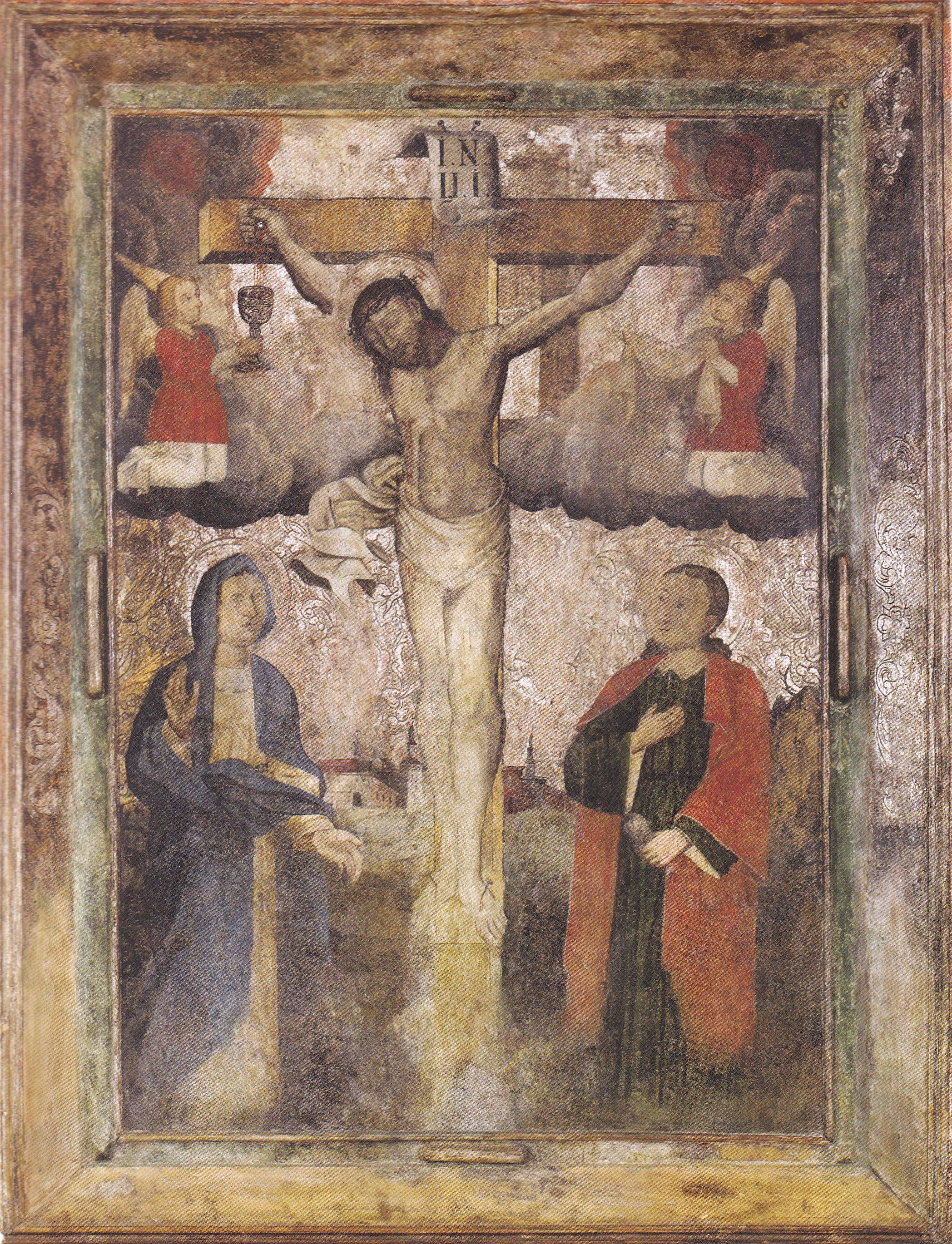
Ікона «Розп’яття»
Розділ: Волинська ікона
Ікона «Розп’яття» (поч. XVIII ст.)
м. Луцьк, Волинська область
При написанні образу автор користувався західноєвропейською гравюрою як зразком. Христос зображується померлим: увінчана терновим вінцем голова схилена до правого плеча, очі закриті, тіло, змучене стражданнями, провисає під власною вагою. Момент умирання на хресті, відображений в іконографії, ніби підтверджує для віруючих істину про Христа Людину, що померла за них реальною мученицькою смертю. Але і у мертвому Христі продовжував перебувати Святий Дух. Його нетлінне тіло, як живе, виливає потоки крові. Прийняття крові ангелами у потир і плат нагадує про таїнство причастя вином у християнській церкві. Обабіч хреста стоять Богородиця та Іоан у скорботних позах. Драматизм події, яка відбувається, підкреслюють свинцеві хмари та зображення кривавих сонця і місяця у відповідності зі словами Об’явлення: «... І ось, стався великий землетрус, і сонце стало темне, як волосяниця, і місяць став, наче кров» (Об. 6,12). Майстер вдається до об'ємного моделювання постатей та конкретизації простору: на горизонті намальований викінчений архітектурний пейзаж.
Розмір: 150 х 114
Матеріал і техніка: дерево, левкас, темпера, сріблення
Походить з церкви Успіння Пресвятої Богородиці с. Качин Камінь-Каширського району
Джерела:
Текст та ілюстрація з книги:
Розп’яття // Музей Волинської ікони [книга-альбом]. – Київ : АДЕФ-Україна, 2016. – С. 176–177 ; іл.
Див. також:
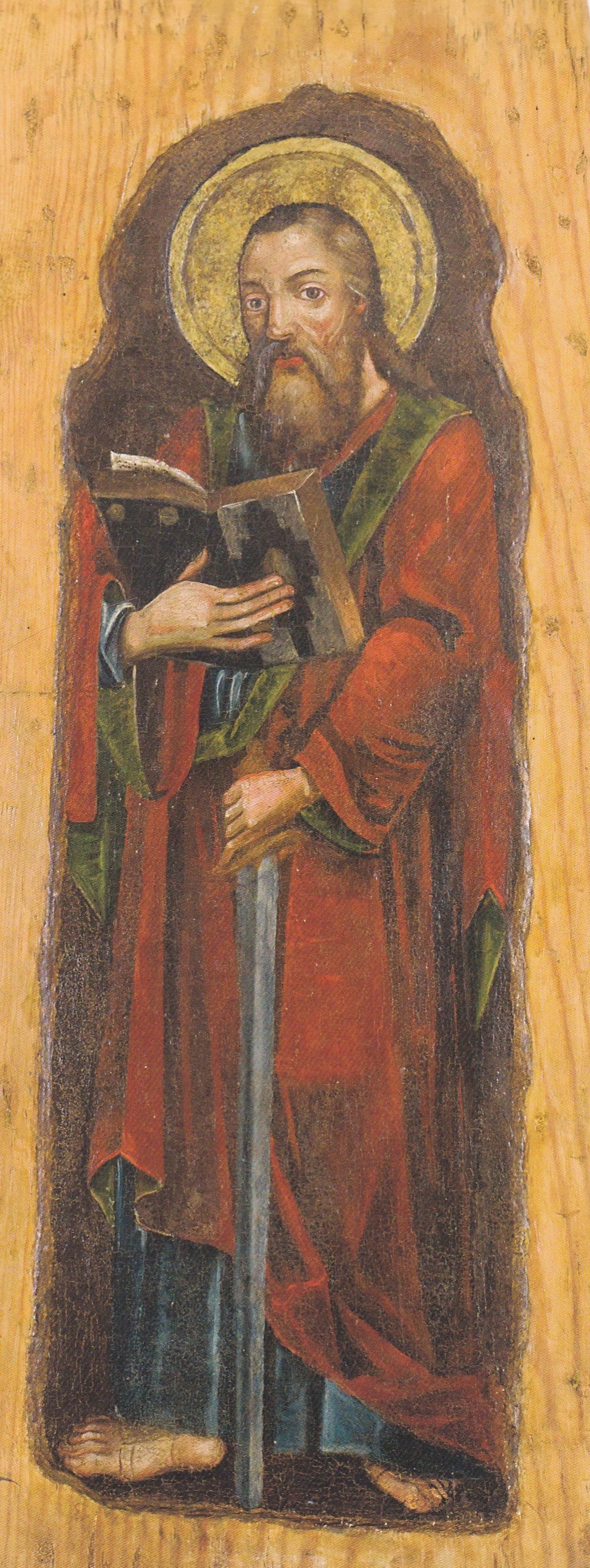
Ікона «Апостол Павло»
Розділ: Волинська ікона
Ікона «Апостол Павло» (друга пол. XVII ст.)
м. Луцьк, Волинська область
Апостол Павло (Савло, Саул) – найвизначніший ранньохристиянський місіонер, «апостол народів» та один з перших богословів християнства, блискучий проповідник, автор багатьох послань. За проповідницьку діяльність він був обезглавлений мечем за часів імператора Нерона.
Зображення апостола Павла на іконі традиційне, упівоберта вправо, з поглядом зверненим до віруючих. Відкрита книга у правій руці вказує на Павла, як автора послань, а опущений додолу меч символізує його мученицьку смерть за віру Христову. Автор прагне передати об’ємність світлотіньовим ліпленням лику і моделюванням драперій зіставленням темних смуг і локальних висвітлень.
Розмір: 81 х 31,5
Матеріал і техніка: дерево, левкас, темпера, кольоровий лак
Походить з церкви Святого Миколая с. Борочиче Горохівського району
Джерела:
Текст та ілюстрація з книги:
Апостол Павло // Музей Волинської ікони [книга-альбом]. – Київ : АДЕФ-Україна, 2016. – С. 180–181 ; іл.
Див. також:
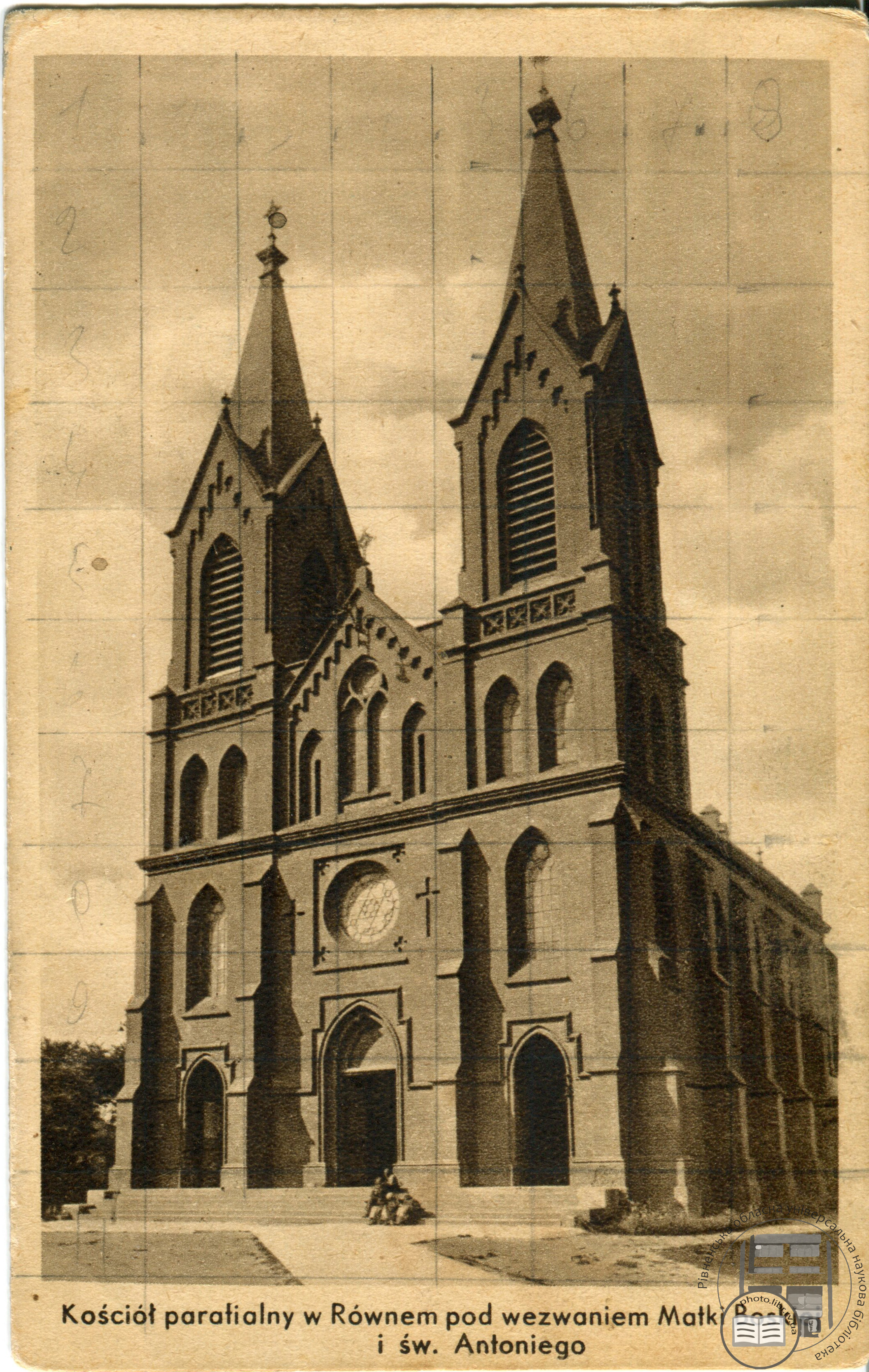
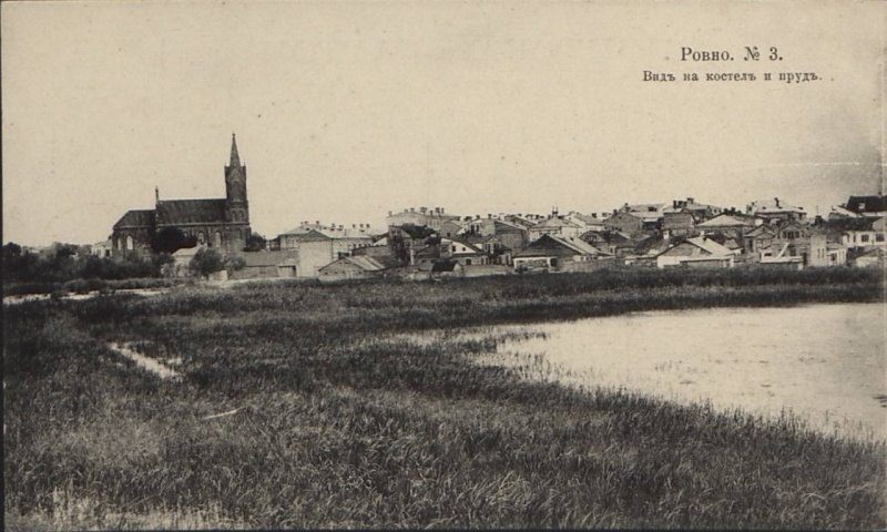
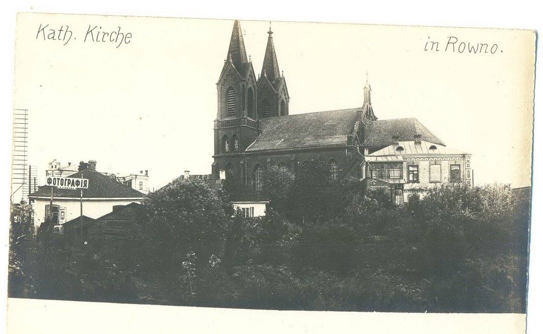
Парафіяльний костел в Рівному на честь Матері Божої і св. Антонія
Розділ: Архітектура Рівненщини
Поштова листівка "Парафіяльний костел в Рівному на честь Матері Божої і св. Антонія". Наклад "Римсько-католицького доброчинного товариства в Рівному".
Приблизний період: 1910-1919
Перший костел в Рівному з’явився в 1548 році, коли місто перейшло у володіння католички Беати Острозької, удови князя Острозького. Він був дерев’яний і знаходився майже на тому ж місці, що і костел св. Антонія. Ні цей костел, який був знищений татарами у 1569 році, ні два інші, що були побудовані в Рівному, не збереглися. У 1858 році (в деяких джерелах в 1869?) в місті почали будувати новий мурований костел з червоної цегли у неоготичному стилі. На рахунок того, хто фінансував це будівництво теж існують різні відомості (дехто пише, що будівництво розпочалося на пожертви князя Казимира Любомирського, дехто вважає, що будівництво фінансував князь Роман Сангушко зі Славути, а рівненський історик Олена Прищепа в своїй книзі «Вулицями Рівного» пише, що будівництво здійснювалося в основному на пожертви прихожан. Добудували костел Святого Антонія Падуанського лише в 1899 році. Освячення відбулося 7 жовтня 1900 року. Будівництвом керував польський архітектор Костянтин Войцеховський. Будову увінчували два вишукані шпилі, фасад прикрашав круглий годинник, а інтер’єр був декорований оригінальними фресками.
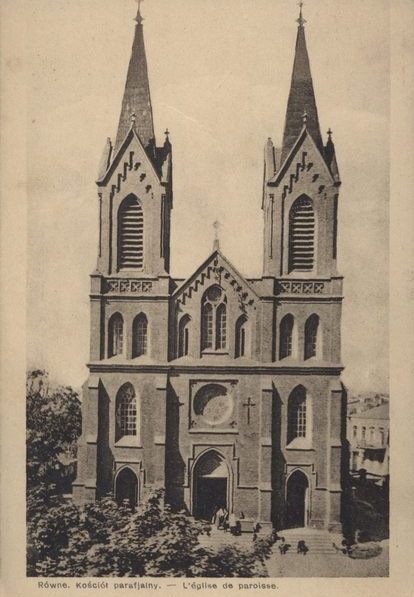
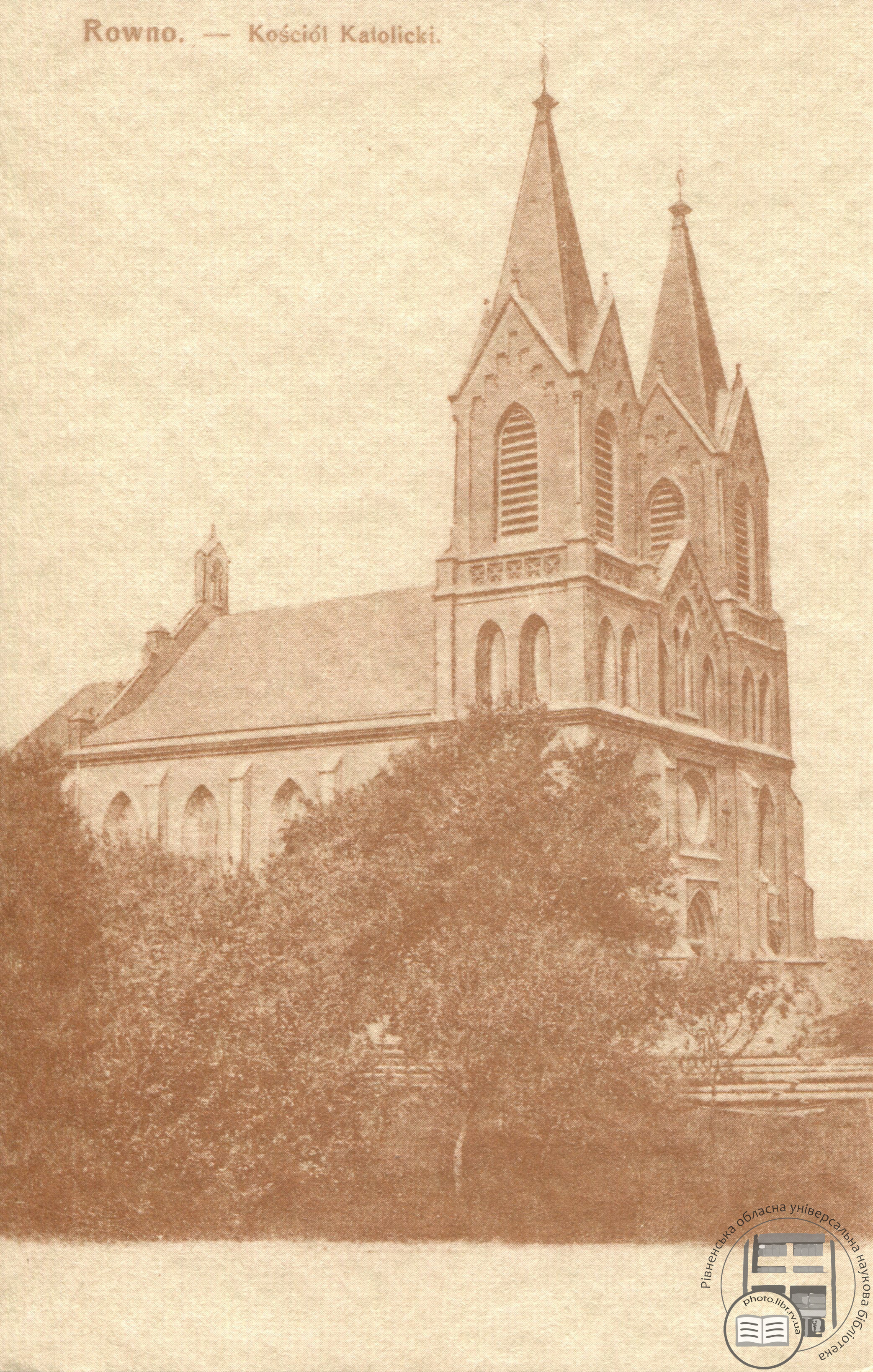
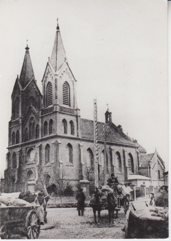
Під час Першої світової війни костел зазнав пошкоджень і був відновлений у 1927 році.
У 1958 році костел Святого Антонія був закритий радянською владою. Після декількох перебудов з костелу зникли хрести, готичні шпилі, внутрішнє та зовнішнє оздоблення. Рівненський журналіст Микола Несенюк пригадував, як він в дитинстві бавився тут з хлопцями дивними трубками, які валялися неподалік в кущах, і призначення яких їм було невідоме. Виявилося, що це були залишки безжально зламаного радянською владою храмового органу. Що ж стосується історичних цінностей, то в костельних підземеллях тривалий час (до самого його закриття) містились поховання родини Любомирських, які теж були знищені.
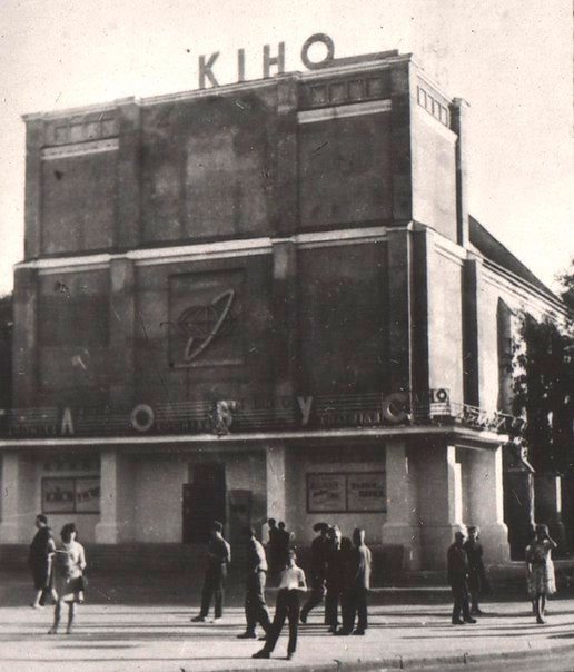
Костел був перетворений на склад, а з кінця 60-х по 1980 рік в цьому приміщенні функціонував кінотеатр Глобус. У 1987 році після ремонтно-реставраційних робіт в приміщенні бувшого костелу відкрився Зал камерної та органної музики.
Цікавою є історія придбання містом нового органу. Виготовлений він був за індивідуальним проектом чехословацькою фірмою «Рігер-Клосс» у 1989 році і призначався Красноярській філармонії. А в Рівному цей інструмент з’явився за сприяння відомої естрадної виконавиці Ірини Понаровської, що якийсь час працювала в Рівненській філармонії. Маючи впливових прихильників свого таланту вона погодилася звернутися в міністерство культури Радянського Союзу з проханням про виділення музичного інструменту філармонії міста Рівне. Як згадував тодішній директор філармонії Святослав Мельничук, втілення цієї фантастичної ідеї в життя, вважали майже нереальним, оскільки орган був дуже дорогим. Коштував він 1,5 млн доларів. Та, оскільки приміщення Красноярської філармонії не було вчасно добудоване, а орган необхідно було терміново забирати з Чехословаччини, державні функціонери, зваживши на клопотання відомої співачки, прийняли рішення відправити інструмент у Рівне. Так у 1989 році в місті знову з’явився орган. З 1993 року ця будівля являється пам’ятником архітектури місцевого значення.
Розмір: 9х14 см
Правове регулювання: Оригінал зберігається в архіві родини Ірини Ігорівни Мелещук (Жилінської), доньки Ігоря Жилінського
Місце розташування: вулиця Соборна, 137, Рівне
Джерело: Проєкт РОУНБ «Рівне та рівняни у фотографіях. Цифрова пам'ять Рівного»
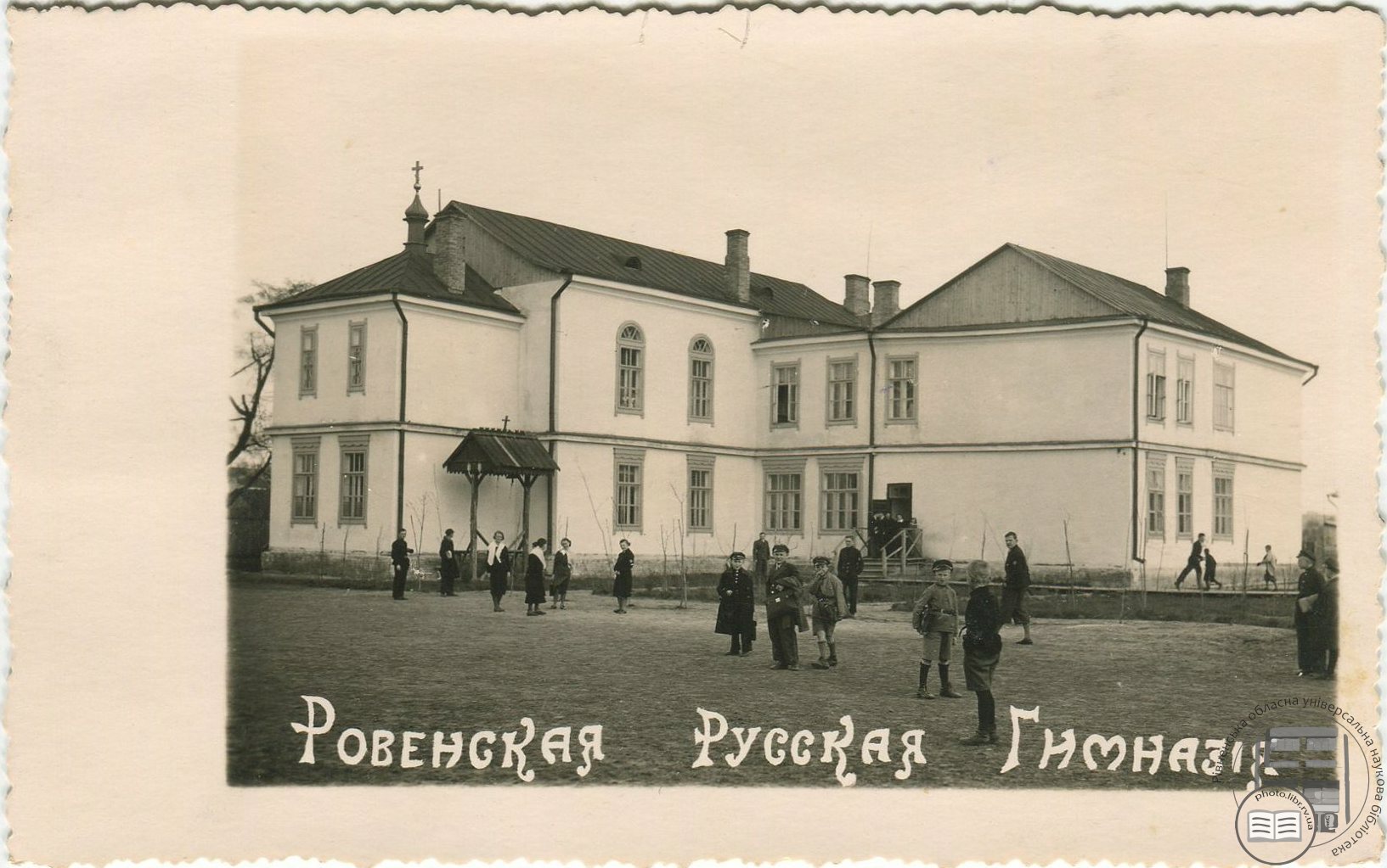
Рівненська російська гімназія / Ровенская русская гимназія
Розділ: Архітектура Рівненщини
Приблизний період:
1926-1935 рр.
Рівненська російська гімназія («Ровенская русская гимназія») Рівненського російського благодійного товариства («Ровенскага русскага благотворительнага общества»), яка була розташована на вулиці 13-ї Дивізії, 53 (нині сучасна будівля банку «Аваль» / Райффайзен Банк). Гімназія була побудована за кошти барона Ф. Штейнгеля
Місце зйомки:
вулиця Симона Петлюри, 35, Рівне
Розмір: 14х9 см
Правове регулювання:
Оригінал зберігається в архіві родини Тетяни Лукашевич
Джерело: Проєкт РОУНБ «Рівне та рівняни у фотографіях. Цифрова пам'ять Рівного»
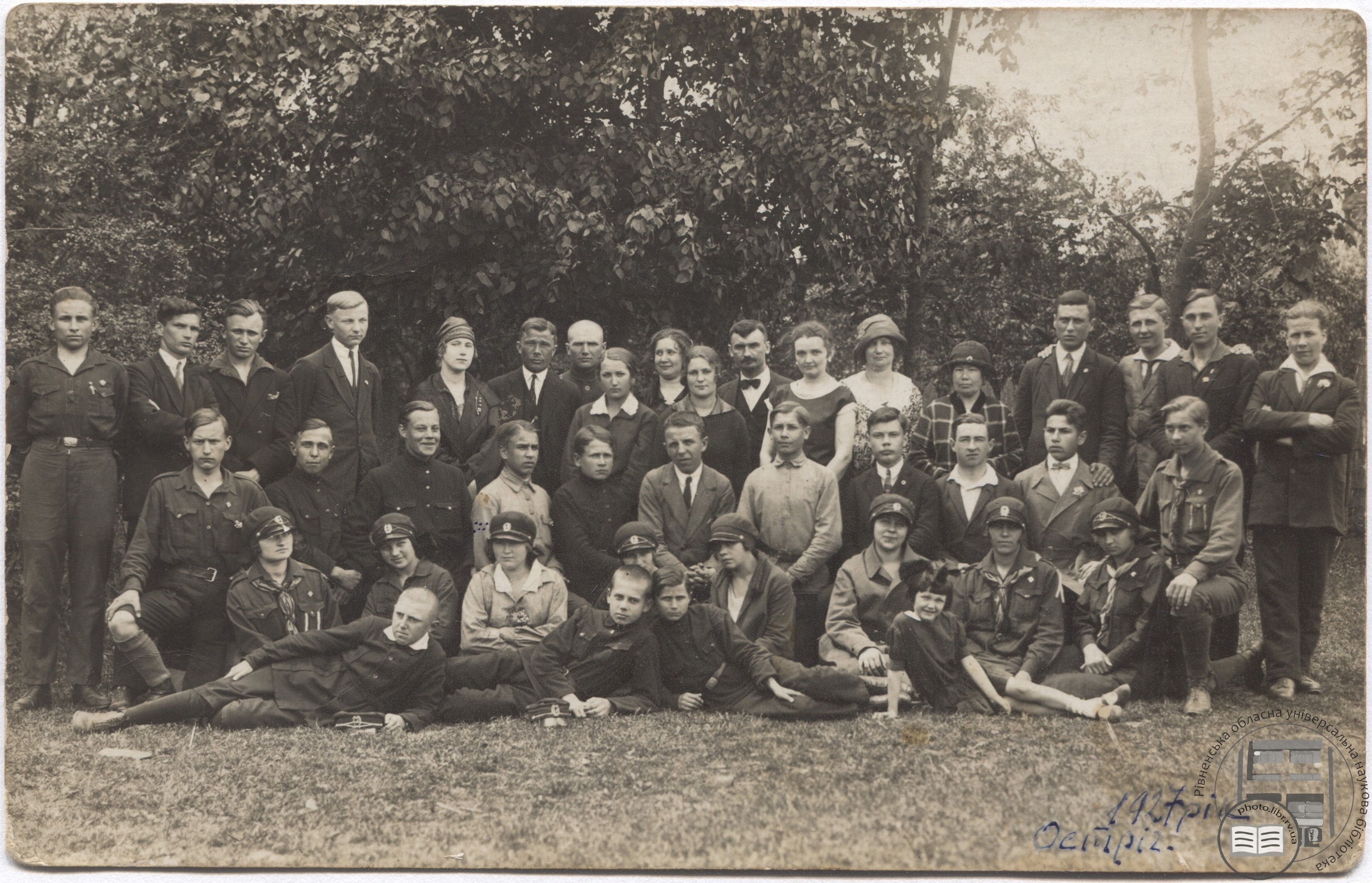
Учні та викладачі Рівненської української гімназії під час подорожі до Острога
Розділ: Видатні діячі
Рік: 1927
Учні та викладачі Рівненської української гімназії під час подорожі до Острога.
Рукописний напис: «Памятка з шкільних часів у Рівному. Прогулька Української Рівенської Гімназії до Острога в 1927 р.».
В 1-му ряду (зверху) 6-й зліва - Гуцуляк Михайло Васильович (15 липня 1894 р. - 28 вересня 1976 р.) - український історик та географ, доктор географічних наук, громадський діяч, член ВУАН та Українського історичного товариства, голова осередку Наукового товариства імені Т. Г. Шевченка у Ванкувері. З жовтня 1926 викладав історію та географію в Рівненській українській гімназії, яку згодом очолив. На цій посаді перебував до 1939 року. Улітку 1948 року емігрував разом з родиною до канадського Ванкувера.
У 2-му ряду 4-й праворуч - Волошин Ростислав Павлович (інколи Березюк-Волошин, псевдо: «Павленко», «Горбенко», «Борисенко», «Левченко», «Чепіга») - український студентський діяч, військовик, полковник Української Повстанської Армії, командант запілля УПА, заступник Головного командира УПА, Генеральний Секретар Внутрішніх Справ УГВР, Голова СУСОП, Лицар Золотого Хреста Заслуги УПА (посмертно). Народився 3 листопада 1911 р. в с. Озеряни, нині Дубенський район, Рівненська область. Загинув 22 серпня 1944 р. в с. Гаї Бійничі, нині Дрогобицький район, Львівська область.
Зворотня сторона фото:
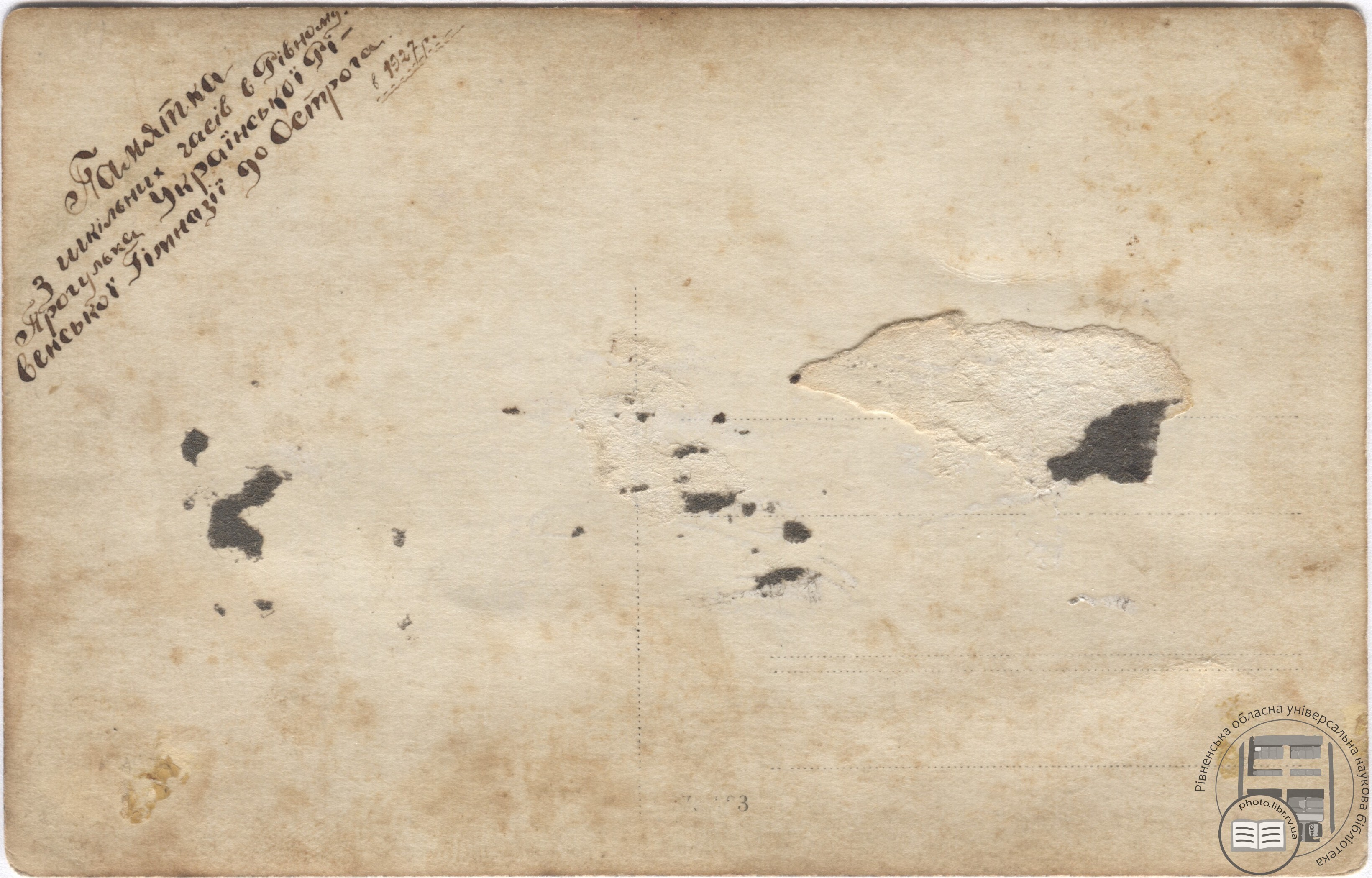
Місце зйомки:
м. Острог, Рівненська область
На фото (зліва направо):
1-й ряд (зверху): Ворник (Ворнік) Степан (конфідент поліції, доля невідома); Ярмак Юрій (емігрував); Торобій Олександр (загинув); Бляхарчук Михайло (загинув); невідома; 6-й зліва - Гуцуляк Михайло Васильович (15 липня 1894 р. - 28 вересня 1976 р.); невідомий; невідома; Ніна Павлівна Прокопович-Річинська (можливо); Невідома; 11-й зліва - Річинський Арсен Васильович (12 (25) червня 1892 р. — 13 квітня 1956 р.) невідома; Голенкіна Євгенія - в 1942 р. вчителювала в торговельній школі Рівного (подальша доля невідома); невідома; Нестеренко Дмитро (емігрував); 16- зліва (3-й праворуч) Горохович Ростислав – в 1942 р. викладав хімію в Березному Тижук Федір – емігрував, став доктор медичних наук в Канаді; Мельничук Олександр (загинув);
2-й ряд: Бондарчук Арсеній (загинув); невідомий; 3-й зліва - Робітницький Теодосій - емігрував в Австралію; 4-й зліва - Данилюк Павло Іванович (1909-1991) був репресований; троє невідомих; 8-й зліва (4-й праворуч) Волошин Ростислав Павлович (1911-1944) невідомий; невідомий; 11-й зліва (1-й праворуч) Іллюк Сергій – (репресований, емігрував до США);
З-й ряд: Оболонська Катерина – вчителювала в Україні; Зброжек Ольга – в Україні; Шевчук Людила – доля невідома; 4-та зліва – Горохович Антоніна Тихонівна (2 березня 1913 р. – 3 квітня 1997 р. м. Торонто, Канада) Якимчук Галина – доля невідома; Аксьонова Євгенія – доля невідома; Ковбаса Анна – в Україні; Тижук Лідія – вчителювала в Україні;
4-й ряд: Робітницький – доля невідома; невідомий; невідомий; невідома дівчинка.
Правове регулювання:
Оригінал зберігається в архіві родини Данилюка Володимира Павловича
Джерело: Проєкт РОУНБ «Рівне та рівняни у фотографіях. Цифрова пам'ять Рівного»
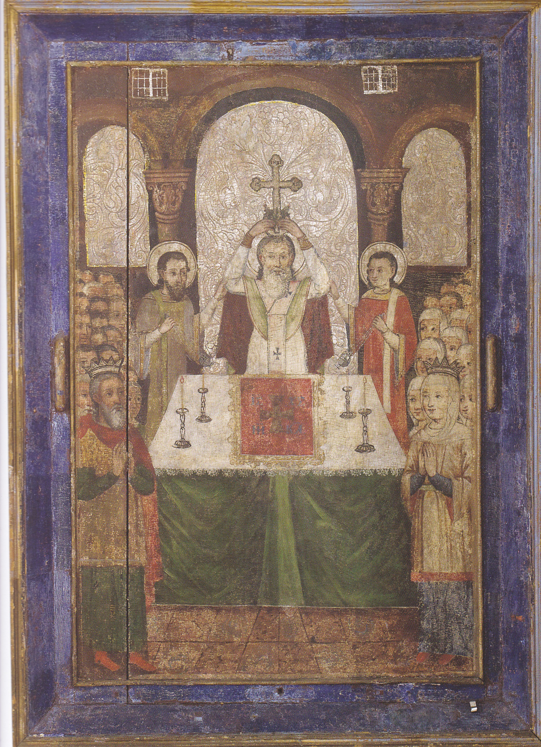
Ікона «Воздвиження чесного хреста»
Розділ: Волинська ікона
Ікона «Воздвиження чесного хреста» (поч. XVIII ст.)
м. Луцьк, Волинська область
В основі сюжету – віднайдення у IV ст. імператрицею Оленою хреста, на якому був розіп’ятий Ісус Христос, і воздвиження його єпископом Макарієм у Єрусалимському храмі.
Іконописець своєрідно передає момент урочистого богослужіння. У центрі зображений тетрапод (грец. чотириножник) – стіл, на який покладений воздух із зображенням хреста і написом «ІС ХС НІКА» – «Ісус Христос перемагає». Урочисто підносить Макарій над головою хрест, воздвигаючи його над світом. У служінні йому допомагають диякони. Нижче, обабіч тетраподу – імператор Костянтин та імператриця Олена у коронах, а за ними безконечним потоком заповнюють храм люди, які прийшли побачити хрест. Просвітлені лики персонажів виражають радість Воздвиження хреста, який із знаряддя смерті Спасителя став знаряддям спасіння людства.
Розмір: 127 х 93
Матеріал і техніка: дерево, левкас, темпера, гравіювання, сріблення
Походить з церкви Воздвиження Чесного Хреста с. Козлиничі Ковельського району
Джерела:
Карпюк Л. Воздвиження чесного хреста [Електронний ресурс] / Л. Карпюк // Волинська єпархія Української Православної Церкви України : [сайт]. – Режим доступу: https://www.pravoslaviavolyni.org.ua/stattia/416-vozdvyzhennia-chesnoho-khresta/. – Назва з екрана.
Текст та ілюстрація з книги:
Воздвиження чесного хреста // Музей Волинської ікони [книга-альбом]. – Київ : АДЕФ-Україна, 2016. – С. 174–175 ; іл.
Див. також:
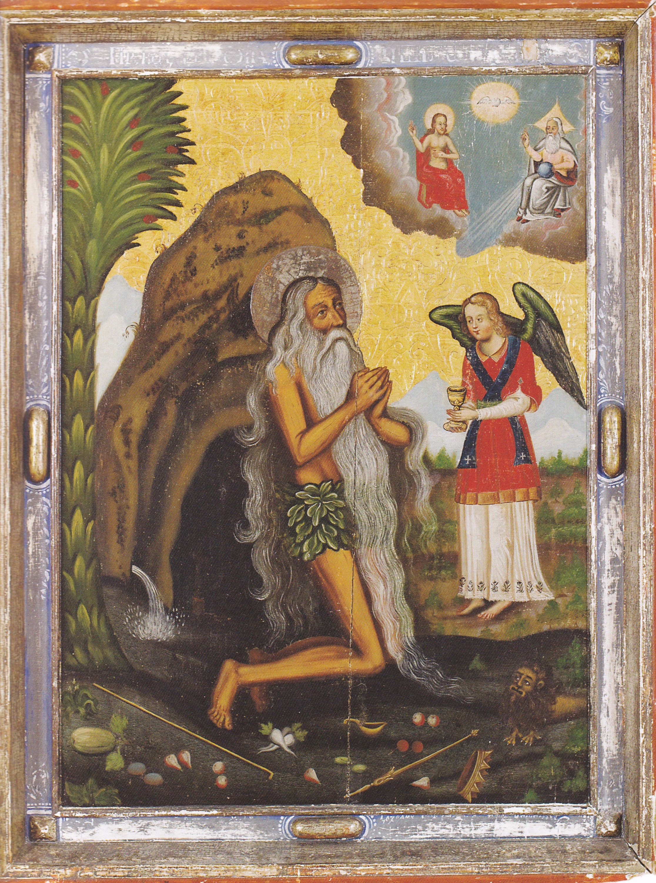
Ікона «Причащання святого Онуфрія»
Розділ: Волинська ікона
Рік: 1717
Ікона «Причащання святого Онуфрія» (1717)
м. Луцьк, Волинська область
Маляр з Михнівки
Святий Онуфрій – легендарний пустельник і аскет IѴст., який провів шістдесят років у Єгипетській пустелі у повній самоті. Культ Святого Онуфрія набув поширення на Волині у XVIII ст. з прийняттям унії. Масове виготовлення ікон і скульптур Святого пов'язане із зростанням кількості монастирів, покровителем яких він вважався.
Образ Святого Онуфрія на іконі повністю відповідає житійній оповіді: він відмовився від наслідування царського престолу (корона і скіпетр кинуті під ноги), присвятив себе Богу (приймає причастя від ангела), його годував ворон (овочі і фрукти на поземі), лев вирив йому могилу. Простір ікони ніби розкривається навколо постаті молільника: золоте тло підкреслює блакить засніжених гір та зелень дерев на задньому плані. Святий Онуфрій поданий просвітленим, відреченим від земних страстей. З його образом контрастує зображення ангела з повновидим молодим обличчям, у якому поєднуються свіжість юності і земна привабливість. Живопис щільний, фарби насичені і повнозвучні.
Розмір: 108,5 х 84
Матеріал і техніка: дерево, левкас, темпера, олія, гравіювання, сріблення, золочення
Походить з церкви Стрітення Господнього с. Михнівка Камінь-Каширського району
Джерела:
Єлісєєва Т. Ікона «Причащання святого Онуфрія» [Електронний ресурс] / Т. Єлісєєва // Волинська єпархія Православної Церкви України : [сайт]. – Режим доступу: https://www.pravoslaviavolyni.org.ua/stattia/364-ikona-prychashchannia-sviatoho-onufriia/. – Назва з екрана.
З колекції Музею волинської ікони: «Причащання Св. Онуфрія» [Електронний ресурс] // Волинський краєзнавчий музей : [сайт]. – Режим доступу: https://volyn-kray-mus.at.ua/news/z_kolekciji_muzeju_volinskoji_ikoni_prichashhannja_sv_onufrija/2020-04-28-2245. – Назва з екрана.
Текст та ілюстрація з книги:
Причащання святого Онуфрія // Музей Волинської ікони [книга-альбом]. – Київ : АДЕФ-Україна, 2016. – С. 170–173 ; іл.
Див. також:
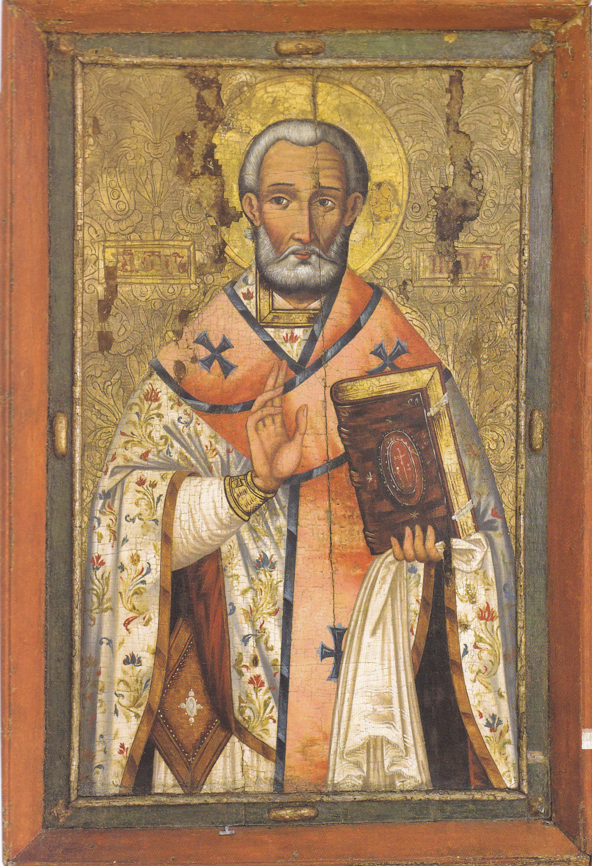
Ікона «Святий Миколай»
Розділ: Волинська ікона
Ікона «Святий Миколай» (XVII ст.)
м. Луцьк, Волинська область
Ha іконі Святитель зображений у одежах православного ієрея, що вказує на служіння, якому він присвятив своє життя. Спокій, мудрість і духовна сила – у погляді його очей. Світлом наповнені його лик, змальований темно-рожевою вохрою, і рука, піднята у благословенні. Сріблом лягає навколо лику тонко прописане ледь хвилясте волосся. Легкий квітковий орнамент на фелоні у поєднанні з рослинним візерунком золотого тла, із золотими німбом і обрізом книги творять вражаючий декоративний ефект.
Розмір: 117 х 80
Матеріал і техніка: дерево, левкас, темпера, гравіювання, сріблення
Походить з церкви Різдва Пресвятої Богородиці с. Чорніїв Турійського району
Джерела:
Єлісєєва Т. Ікона «Святий Миколай» [Електронний ресурс] / Т. Єлісєєва // Волинська єпархія Православної Церкви України : [сайт]. – Режим доступу: https://www.pravoslaviavolyni.org.ua/stattia/346-ikona-sviatyi-mykolai/. – Назва з екрана.
Текст та ілюстрація з книги:
Святий Миколай // Музей Волинської ікони [книга-альбом]. – Київ : АДЕФ-Україна, 2016. – С. 168–169 ; іл.
Див. також:
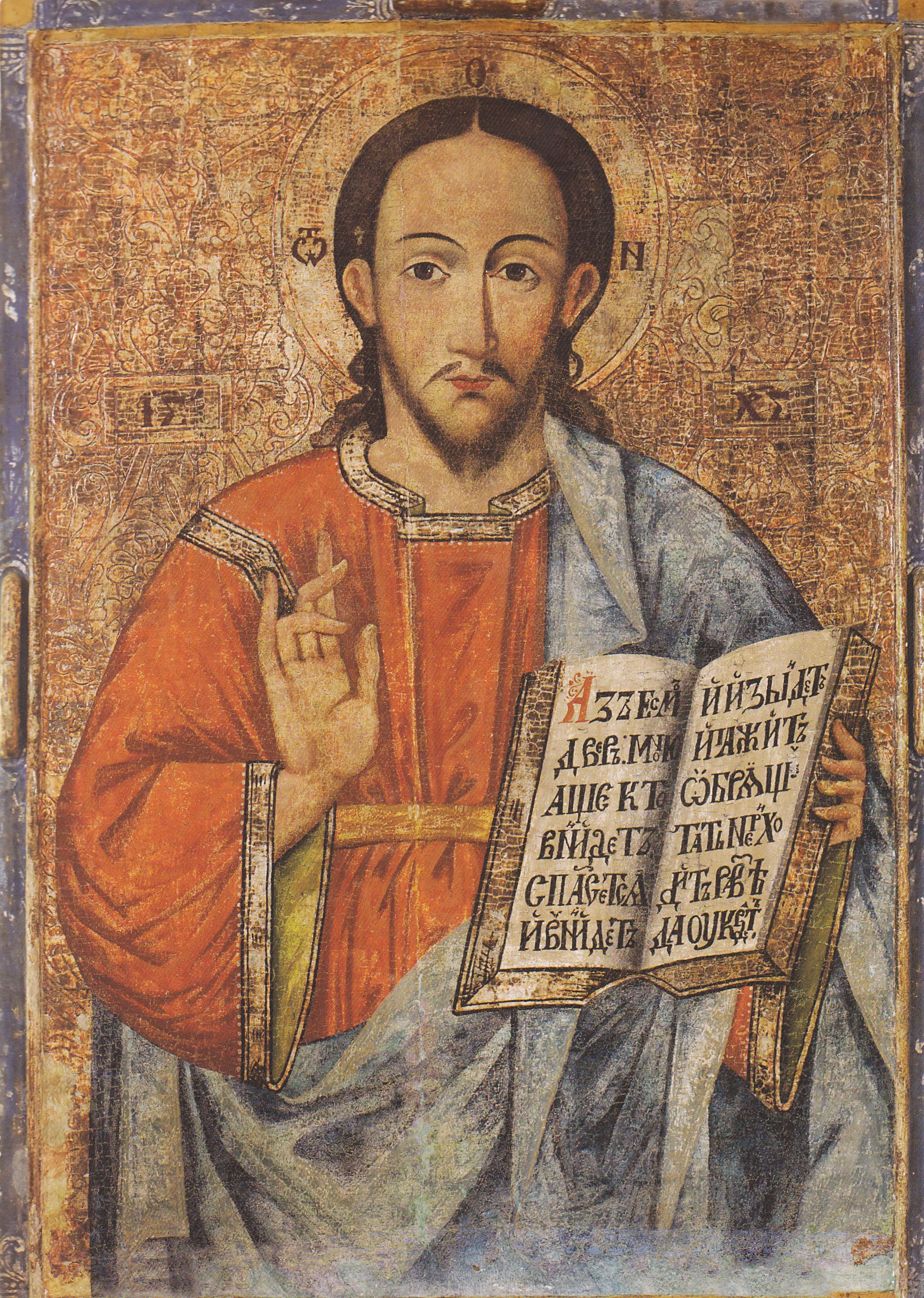
Ікона «Христос Вседержитель»
Розділ: Волинська ікона
Ікона «Христос Вседержитель» (кін. XVII ст.)
м. Луцьк, Волинська область
Маляр з Михнівки
Образ Спаса написаний у сталих іконографічних традиціях волинського іконопису XVII ст. Дотримуючись канону у зображенні лику, пози, атрибуту і одеж Христа, іконописець створює споглядальний, сповнений смутку, світлий образ, використовуючи майже пастельні відтінки червоного і блакитного кольорів у поєднанні зі сріблом тасьми, обрізу книги і гравійованого виноградом тла. Привертає увагу майстерно зроблений напис на книзі, що містить цитату з Євангелія: «Я є двері: хто через Мене увійде, той спасеться...» (Ін. 10,9) текст, який зрідка зустрічається на волинських іконах.
Розмір: 92 х 66
Матеріал і техніка: дерево, левкас, темпера, гравіювання, сріблення
Походить з церкви Архістратига Михаїла с. Дроздні Ковельського району
Джерела:
Текст та ілюстрація з книги:
Христос Вседержитель // Музей Волинської ікони [книга-альбом]. – Київ : АДЕФ-Україна, 2016. – С. 166–167 ; іл.
Див. також:
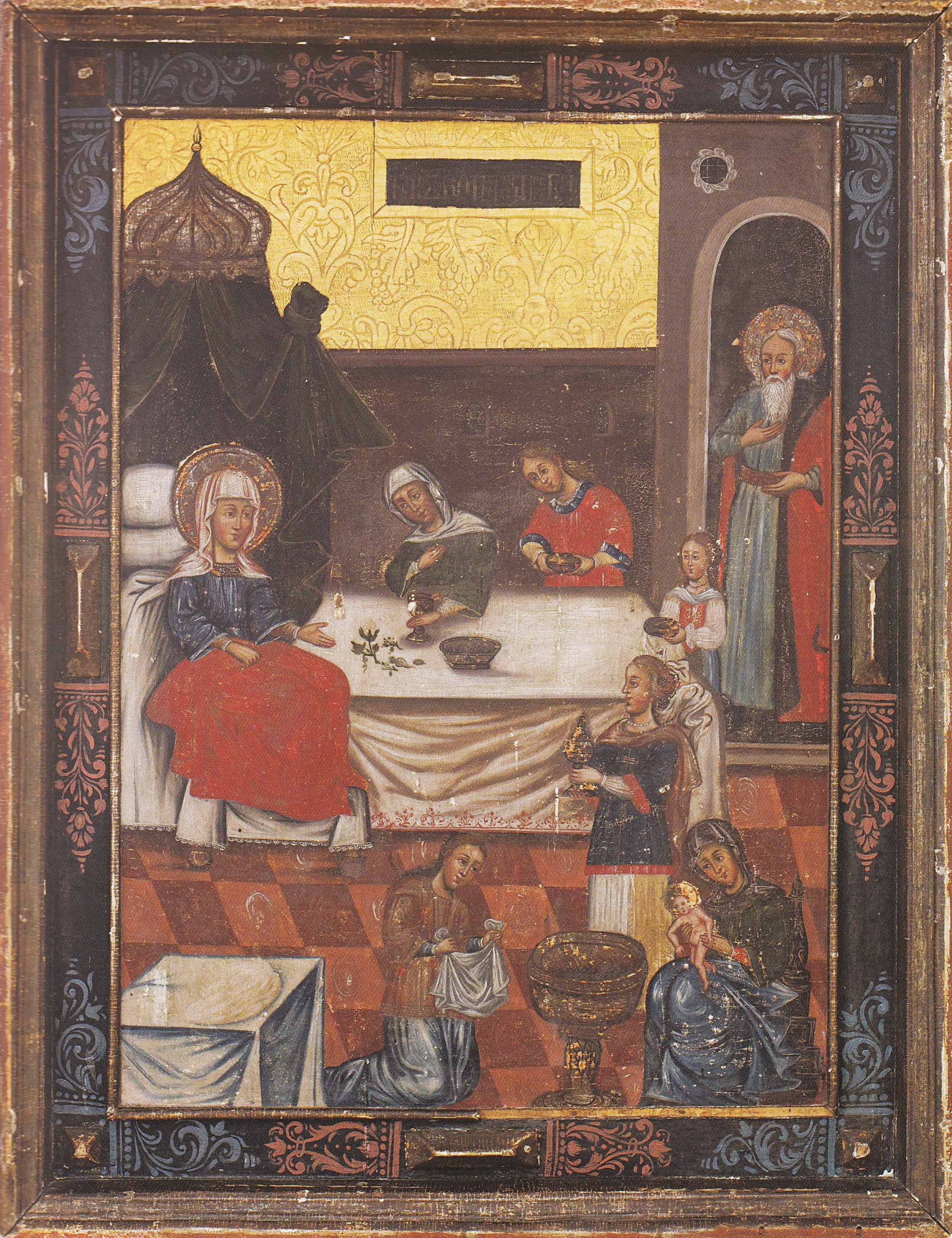
Ікона «Різдво Богородиці»
Розділ: Волинська ікона
Ікона «Різдво Богородиці» (кін. XVII ст.)
м. Луцьк, Волинська область
Маляр з Михнівки
Автор ікони, спираючись на давній канон, подає реальну подію – народження Марії, сповнене любові і тихого спокою. Золотом – знаком вічного світла – зроблений напис, який іменує ікону. Золото різьбленого тла ніби освітлює все зображення: Анну на білосніжному ложі, Іоакима у дверях власного дому, дів з дарами, сцену омовіння новонародженої. Стримано сяє срібло на німбах, ніжно відсвічується червоний колір в одежах, лагідні і простодушні лики, пластичні жести – все це примножує величний у своїй радості зміст події – народження Богоматері.
Розмір: 109 х 86
Матеріал і техніка: дерево, левкас, темпера, гравіювання, золочення
Походить з церкви Різдва Пресвятої Богородниці с. Сошичне Камінь-Каширського району
Джерела:
Обухович Л. Ікона «Різдво Богородиці» [Електронний ресурс] / Л. Обухович // Волинська єпархія Української Православної Церкви Київського Патріархату : [сайт]. – Режим доступу: https://www.arkhiv.pravoslaviavolyni.org.ua/gazeta/stattja/?newsid=1268. – Назва з екрана.
Текст та ілюстрація з книги:
Різдво Богородиці // Музей Волинської ікони [книга-альбом]. – Київ : АДЕФ-Україна, 2016. – С. 162–165 ; іл.
Див. також: